Nestled in the northern region of Costa Rica lies the majestic Arenal Volcano, a towering natural wonder that has captivated visitors for decades. With its verdant forests, cascading waterfalls, and bubbling hot springs, the Arenal area is a must-see destination for any traveler seeking an authentic taste of Costa Rican culture and natural beauty. And as it crowns a great region, it has several ways to reach it, from wherever you are coming. 

But with so many different routes to get to the volcano, it can be challenging to know where to start. In this article, we'll explore the various ways to reach the Arenal Volcano, highlighting the unique features and benefits of each option.

Guanacaste International Airport (LIR)

The Arenal Volcano Region is 2 hours 43 minutes from the 

Guanacaste International Airport.

142.9 Km | 88.7 miles

Juan Santamaria International Airport (SJO)

The Arenal Volcano is 2 hours and 29 minutes from the 

Juan Satamaría International Airport

114.3 Km | 70 Miles


From or To Arenal

the routes to get to arenal:

The Arenal Volcano Region has five distinct routes that are used by travelers and locals every day.

Coming from San José and the Central Pacific.

Coming from Monteverde or the Nicoya Peninsula and Guanacaste.

Coming from the Northern Area: Bijagua, Guatuso, Boca Tapada and Caño Negro.

Coming from The Caribbean, Sarapiqui, or Turrialba.


HOW TO GET TO THE ARENAL VOLCANO?

DEPENDING ON WHERE YOU ARE COMING FROM, THERE ARE DIFFERENT ROUTES TO FOLLOW TO GET TO THE REGION OF THE VOLCANO, you should take the most picturesque, fast and in good conditions as you can.

If you’re coming from San José, or the central pacific region,you can come through san ramon: 

Panamerican Highway, Route 1: If you are driving, set your Google Maps or Waze in San Ramon. 

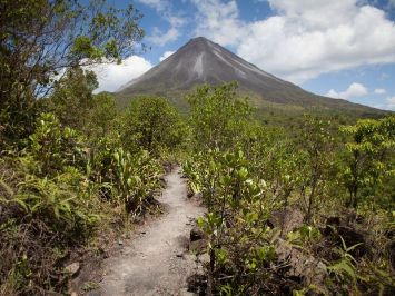
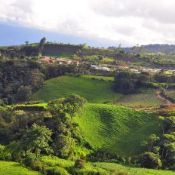
You will pass through the town of San Ramón, and ascend to the Los Ángeles cloud forests; then you will notice that the route starts descending. 

Then you will reach La Tigra, and a little further, and right before the Peñas Blancas River, the road divides. 

The most picturesque and convenient is the one taking the Peñas Blancas River Bridge.

The alternate route will take you past Tanque town and on to La Fortuna, it is less winding, but it will take a bit longer. 

You can also come by the route of the Poás Volcano and the La Paz Waterfall Gardens:

This is called the Vara Blanca route.

Through this route you can go to the Poas Volcano, the popular Waterfalls Garden and go accross the magnificent San Carlos Plains, as luscious as they are progressive. 

And our recommendation is to start early so you can visit everything and enjoy this rainforest-filled route. 

This road will take you into San Miguel and Rio Cuarto. And to the road of Tanque town.

By El Tanque you will already be seeing the mighty volcano if the day is clear.  


Zarcero used to be the old route to Arenal:

The route through Zarcero and Ciudad Quesada goes through some beautiful landscapes and magnificent cloud forests. 

Zarcero has a beautiful and original park in its central square. Dozens of topiary figures have been trimmed and looked after for many years. 

When you take this route, is vital to go early in the day as it gets very foggy at times.

It is a beautiful way to get to Arenal, and you should stop to try the food and delicatessen offered by the side of the road.  

Another route is to go through SarchÍ:

You can go through the towns of Grecia, and Sarchi and its fantastic painted ox carts. From there, you would have to take the route that goes to the town of Bajos del Toro. 

The route is very winding and it has some  steep cliffs on the side, going through the rainforest. 

The town of Bajos del Toro is a real Costa Rican town and you may find some excellent typical restaurants offering fish trout, It also has one of the most beautiful waterfalls in Costa Rica: La Catarata de Bajos del Toro! 

Coming from the Caribbean CoasT:

Tortuguero, Cahuita, Puerto Viejo, Pacuare, Turrialba, or Bajos del Toro in Panamá.

The route is through the area of the Sarapiquí River. A relatively flat region with hundreds of acres dedicated to farming and livestock.  

If you’re coming from the Pacific Coast, Monteverde, Tenorio, or Liberia (LIR) Airport:

You will take the route of Tilarán and drive around the lake until you arrive in La Fortuna.

 There is no way to get lost. 


To wrap it up:

The Arenal Volcano is a vast region, and choices are so many that it is better to count on your Terranova Travel Design. Contact us and book your trip now!

Utilizamos cookies
Preferencias de las cookies
A continuación, encontrará información sobre los propósitos para los cuales nosotros y nuestros socios utilizamos cookies y procesamos datos. Puede establecer sus preferencias para el procesamiento y/o consultar más información en los sitios web de nuestros socios.
Cookies analíticas Desactivar todo
Cookies funcionales
Otras cookies
Utilizamos cookies para personalizar el contenido y los anuncios, proporcionar las funciones que utilizan las redes sociales y analizar nuestro tráfico. Obtener más información sobre nuestra política de cookies.
Entiendo Detalles
Cookies